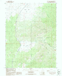
1986 Map of Dog Valley Peak
USGS Topo · Published 1986About this map
Fishlake National Forest encompasses much of this 1980s landscape, where the high desert terrain of Millard County meets significant drainage systems. The topography is dominated by Dog Valley Peak and the surrounding ridgelines that separate Baker Canyon and Widemouth Canyon. The central corridor of Dog Valley contains essential transit landmarks such as the Cove Fort-Dog Valley Pass, which has long served as a critical passage through these mountains. Water features are seasonal and distinct, including the rugged stretch of Thousand Creek at The Narrows and the smaller Dollar Gulch. Economic activity of the mid-20th century is evidenced by several Gravel Pits and a Borrow Pit near the valley floor, alongside a Corral and White Sage Flat, indicating the area's continued use for livestock and resource extraction.
Find a feature on this map
19 named features on this map. Tap any name to fly to it.
Don’t see what you’re looking for? This feature index may not catch every label — zoom into the map to look around manually.
Map Details
Editions of this 1986 Dog Valley Peak Map
This is the sole edition of this map. No revisions or reprints were ever made.
Other maps of this area

1885 · Beaver
USGS Topo · 1:250,000

1932 · Sevier
USGS Topo · 1:62,500

1935 · Sevier
USGS Topo · 1:62,500

1953 · Richfield
USGS Topo · 1:250,000

1958 · Richfield
USGS Topo · 1:250,000

1962 · Fillmore
USGS Topo · 1:62,500

1962 · Tabernacle Hill
USGS Topo · 1:62,500

1962 · Cove Fort
USGS Topo · 1:62,500

1980 · Richfield
USGS Topo · 1:100,000
1981 · Red Ridge
USGS Topo · 1:24,000