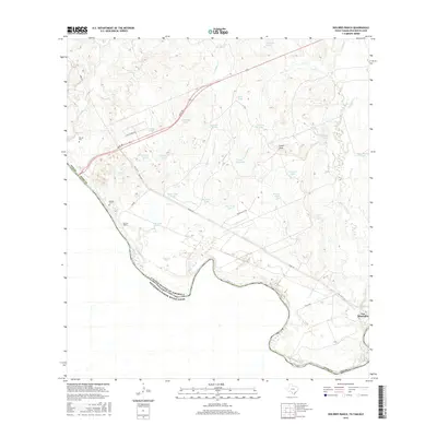
2016 Map of Dolores Ranch
USGS Topo · Published 2016About this map
The Rio Grande forms the international boundary with Mexico in this 2016 survey of the brushlands northwest of Laredo. The landscape is defined by an extensive network of water tanks and ephemeral creek drainages, including Santo Tomas Cr, Los Indios Cr, and Pinto Valle Cr. These features, such as Bull Trap Tank and Escondido Tank, indicate a pastoral economy focused on cattle ranching in a semi-arid environment. Infrastructure is centered around Mines Rd, reflecting the area's historical connection to regional extraction and transit. Settlement is sparse, anchored by the Dolores Ranch and the small community of Los Minerales. Local genealogy is represented by Darwin Cem and Dolores Cem, which sit near the river's edge. Notable landmarks like Lovers Leap overlook the varied terrain of the Rio Grande valley.
Find a feature on this map
41 named features on this map. Tap any name to fly to it.
Don’t see what you’re looking for? This feature index may not catch every label — zoom into the map to look around manually.
Map Details
Editions of this 2016 Dolores Ranch Map
This is the sole edition of this map. No revisions or reprints were ever made.
Other maps of this area

1923 · Palafox
USGS Topo · 1:62,500

1956 · Las Tiendas
USGS Topo · 1:62,500

1956 · Islitas
USGS Topo · 1:62,500

1956 · Laredo
USGS Topo · 1:250,000

1965 · Laredo West
USGS Topo · 1:24,000

1965 · Cuervo Creek
USGS Topo · 1:24,000

1965 · Cerritos Blancos
USGS Topo · 1:24,000

1965 · Nido Ranch
USGS Topo · 1:24,000
1965 · Dolores Ranch
USGS Topo · 1:24,000
1983 · San Pedro Hill
USGS Topo · 1:24,000