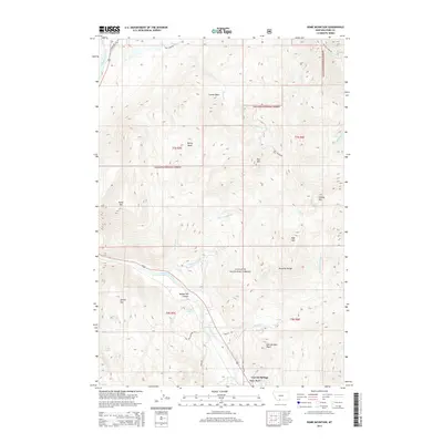
2014 Map of Dome Mountain
USGS Topo · Published 2014About this map
The Yellowstone River carves a dramatic path through this high-elevation landscape, defining the corridor between the northern Absaroka Range and the surrounding peaks of the Gallatin National Forest. This 2014 survey documents a region where transportation history and geography converge at Yankee Jim Canyon, a narrow passage named for a legendary local figure. The settlement of Corwin Springs serves as the primary gateway in the south, positioned near the river and the Old Yellowstone Trl S.
Find a feature on this map
36 named features on this map. Tap any name to fly to it.
Don’t see what you’re looking for? This feature index may not catch every label — zoom into the map to look around manually.
Map Details
Editions of this 2014 Dome Mountain Map
This is the sole edition of this map. No revisions or reprints were ever made.
Other maps of this area

1891 · Livingston
USGS Topo · 1:250,000

1893 · Livingston
USGS Topo · 1:250,000

1947 · Bozeman
USGS Topo · 1:250,000

1948 · Bozeman
USGS Topo · 1:250,000

1955 · Bozeman
USGS Topo · 1:250,000

1955 · Emigrant
USGS Topo · 1:62,500

1955 · Fridley Peak
USGS Topo · 1:62,500
1955 · Gardiner
USGS Topo · 1:62,500
1955 · Miner
USGS Topo · 1:62,500

1958 · Bozeman
USGS Topo · 1:250,000