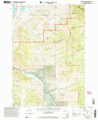
2000 Map of Dome Mountain
USGS Topo · Published 2005About this map
Yellowstone River flows through the heart of this landscape, cutting through the dramatic Yankee Jim Canyon as it moves through Paradise Valley. This survey, revised at the turn of the millennium, illustrates the complex management of public and private lands, including the Dome Mountain Wildlife Management Area and the Gallatin National Forest. The presence of the Game Check Station and an Airstrip near the river indicates the area's ongoing use for wildlife conservation and outdoor recreation. Higher elevations are dominated by landmarks such as Dome Mountain, Sphinx Mountain, and the high ridges of the Absaroka-Beartooth Wilderness. The map also captures local ranching history with the Oto Ranch and Trestle Ranch, while several small alpine lakes like Cutler Lake and Twin Lakes dot the drainage basins of Cedar Creek and Joe Brown Creek.
Find a feature on this map
37 named features on this map. Tap any name to fly to it.
Don’t see what you’re looking for? This feature index may not catch every label — zoom into the map to look around manually.
Map Details
Editions of this 2000 Dome Mountain Map
This is the sole edition of this map. No revisions or reprints were ever made.
Other maps of this area

1891 · Livingston
USGS Topo · 1:250,000

1893 · Livingston
USGS Topo · 1:250,000

1947 · Bozeman
USGS Topo · 1:250,000

1948 · Bozeman
USGS Topo · 1:250,000

1955 · Bozeman
USGS Topo · 1:250,000

1955 · Emigrant
USGS Topo · 1:62,500

1955 · Fridley Peak
USGS Topo · 1:62,500
1955 · Gardiner
USGS Topo · 1:62,500
1955 · Miner
USGS Topo · 1:62,500

1958 · Bozeman
USGS Topo · 1:250,000