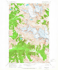
1963 Map of Dome Peak
USGS Topo · Published 1967About this map
Dome Peak stands as the central landmark of this glaciated wilderness, situated at the convergence of several county boundaries in the high Cascades. The 1963 survey captures a landscape dominated by massive ice fields and subalpine lakes, including the expansive South Cascade Glacier and Dana Glacier. These features feed into drainages like Sulphur Creek and the South Fork Cascade River, illustrating the complex hydrology of the region. The map also delineates the high-altitude divide between the Mt Baker National Forest and Okanogan National Forest, marked by sharp summits such as Sinister Peak and Sentinel Peak. Remote water bodies like Itswoot Lake and White Rock Lakes highlight the isolated nature of the terrain before later wilderness designations altered management of these high-country basins.
Find a feature on this map
35 named features on this map. Tap any name to fly to it.
Don’t see what you’re looking for? This feature index may not catch every label — zoom into the map to look around manually.
Map Details
Editions of this 1963 Dome Peak Map
3 editions found
Other maps of this area

1899 · Glacier Peak
USGS Topo · 1:125,000

1901 · Glacier Peak
USGS Topo · 1:125,000

1902 · Stehekin
USGS Topo · 1:125,000

1904 · Stehekin
USGS Topo · 1:125,000

1944 · Holden
USGS Topo · 1:62,500

1949 · Holden
USGS Topo · 1:62,500

1950 · Glacier Peak
USGS Topo · 1:62,500

1955 · Concrete
USGS Topo · 1:250,000

1958 · Concrete
USGS Topo · 1:250,000

1962 · Concrete
USGS Topo · 1:250,000