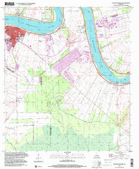
1999 Map of Donaldsonville
USGS Topo · Published 2000About this map
Donaldsonville serves as the focal point of this riverfront landscape, situated where the Mississippi River bends sharply near Bringier Point. The map illustrates a historic transition from the traditional plantation economy to modern industrial land use. Residual signatures of the 19th-century river corridor are visible in the footprints of Dugas Plantation, Union Plantation, and St Mary Plantation. These historical agricultural lands are increasingly occupied by contemporary infrastructure, such as the Sewage Treatment Plant and the extensive Lapice Oil Field to the south.
Find a feature on this map
35 named features on this map. Tap any name to fly to it.
Don’t see what you’re looking for? This feature index may not catch every label — zoom into the map to look around manually.
Map Details
Editions of this 1999 Donaldsonville Map
This is the sole edition of this map. No revisions or reprints were ever made.
Other maps of this area

1892 · Donaldsonville
USGS Topo · 1:62,500

1892 · Thibodaux
USGS Topo · 1:62,500

1927 · Thibodaux NW
USGS Topo · 1:31,680

1932 · Thibodaux NE
USGS Topo · 1:31,680

1935 · Gonzales
USGS Topo · 1:31,680

1936 · White Castle
USGS Topo · 1:62,500

1939 · Donaldsonville
USGS Topo · 1:62,500

1940 · Lagan
USGS Topo · 1:31,680

1940 · Madewood
USGS Topo · 1:31,680

1945 · New Orleans
USGS Topo · 1:250,000