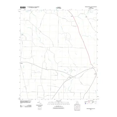
2011 Map of Donalsonville NE
USGS Topo · Published 2011About this map
Mayhaw sits at the western edge of this landscape, which is defined by a dense network of watercourses and rural family cemeteries. Water drainage patterns are dominated by Spring Creek, Cypress Creek, and Aycocks Creek, while smaller tributaries like Sow Branch and Susian Ford Creek weave through the agricultural land. This map reflects the long-standing rural community structure of Miller County, evidenced by several scattered burial grounds including New Salem Cemetery, Roberts Cemetery, and Cratic Cemetery. The terrain is interconnected by a grid of named local routes such as Stein RD, Womble RD, and Three Notch RD, illustrating the persistent agrarian layout of the region. The proximity of Flat Creek Cemetery to its namesake Flat Creek suggests a settlement pattern deeply tied to the local hydrology, where early families established roots along these minor waterways.
Find a feature on this map
52 named features on this map. Tap any name to fly to it.
Don’t see what you’re looking for? This feature index may not catch every label — zoom into the map to look around manually.
Map Details
Editions of this 2011 Donalsonville NE Map
This is the sole edition of this map. No revisions or reprints were ever made.
Other maps of this area

1953 · Dothan
USGS Topo · 1:250,000

1954 · Dothan
USGS Topo · 1:250,000

1955 · Dothan
USGS Topo · 1:250,000

1973 · Blakely South
USGS Topo · 1:24,000

1973 · Hentown
USGS Topo · 1:24,000

1974 · Boykin
USGS Topo · 1:24,000

1974 · Donalsonville NE
USGS Topo · 1:24,000

1974 · Damascus
USGS Topo · 1:24,000
1974 · Donalsonville East
USGS Topo · 1:24,000
1974 · Colquitt
USGS Topo · 1:24,000