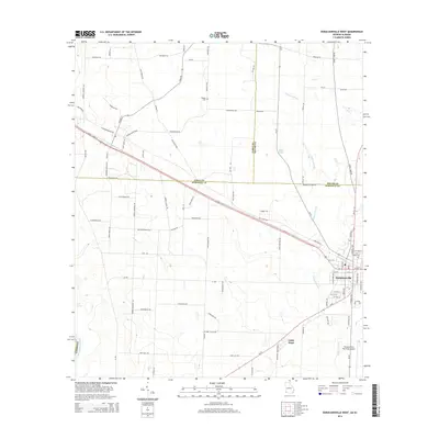
2014 Map of Donalsonville West
USGS Topo · Published 2014About this map
The Chattahoochee River defines the western edge of this Seminole County landscape, where the agricultural flats of southwest Georgia meet the Alabama border. In the southeastern corner, the town of Donalsonville serves as a local hub, situated at the junction of Us-84, Ga-91, and Ga-39. The map reveals a dense network of rural roads named for local families and landmarks, such as Dot Harvey Rd, Snake Nation Rd, and Pot Likker Ln, reflecting a deeply rooted agricultural community. Notable local sites include Little Hope and the Donalsonville Municipal Airport. Several water features, including Fishpond Drain, Byrd Pond, and Carr Spring, punctuate the terrain. Local history is preserved at Oak Cem and Hodges Cem, while the county lines between Early, Miller, and Seminole counties provide further geographical context to this transition zone between the river and the town.
Find a feature on this map
93 named features on this map. Tap any name to fly to it.
Don’t see what you’re looking for? This feature index may not catch every label — zoom into the map to look around manually.
Map Details
Editions of this 2014 Donalsonville West Map
This is the sole edition of this map. No revisions or reprints were ever made.
Other maps of this area

1952 · Bascom
USGS Topo · 1:24,000

1953 · Dothan
USGS Topo · 1:250,000

1954 · Dothan
USGS Topo · 1:250,000

1954 · Steam Mill
USGS Topo · 1:24,000

1954 · Desser
USGS Topo · 1:24,000

1954 · Tallahassee
USGS Topo · 1:250,000

1955 · Dothan
USGS Topo · 1:250,000

1959 · Tallahassee
USGS Topo · 1:250,000

1960 · Tallahassee
USGS Topo · 1:250,000

1970 · Gordon
USGS Topo · 1:24,000