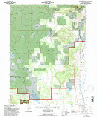
1993 Map of Donica Mountain
USGS Topo · Published 1996About this map
Modoc National Forest dominates this northeastern California landscape, where the Pit River cuts through the eastern edge of the quadrangle. The terrain is defined by volcanic features and high-altitude water management, evidenced by numerous basins such as Joiner Reservoir, Upper Roberts Reservoir, and Hines Reservoir. Notable summits including Donica Mountain and Splawn Mountain rise above the surrounding timberlands and flats like Armentrout Flat.
Find a feature on this map
24 named features on this map. Tap any name to fly to it.
Don’t see what you’re looking for? This feature index may not catch every label — zoom into the map to look around manually.
Map Details
Editions of this 1993 Donica Mountain Map
This is the sole edition of this map. No revisions or reprints were ever made.
Other maps of this area

1886 · Modoc Lava Bed
USGS Topo · 1:250,000

1892 · Modoc Lava-Bed
USGS Topo · 1:250,000

1954 · Alturas
USGS Topo · 1:250,000

1958 · Alturas
USGS Topo · 1:250,000

1961 · Bieber
USGS Topo · 1:62,500

1961 · Fall River Mills
USGS Topo · 1:62,500

1962 · Alturas
USGS Topo · 1:250,000

1962 · Crank Mountain
USGS Topo · 1:62,500

1962 · White Horse
USGS Topo · 1:62,500

1965 · Alturas
USGS Topo · 1:250,000