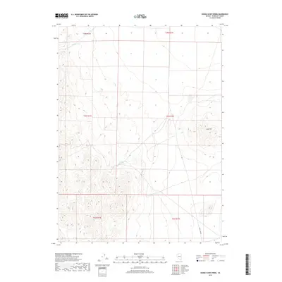
2018 Map of Donna Schee Spring
USGS Topo · Published 2018About this map
Donna Schee Spring and Noble Spring serve as the primary hydrologic landmarks in this arid stretch of Humboldt County, positioned along the western slopes of the Jungo Hills. The terrain is defined by a sparse network of natural drainage and man-made infrastructure, most notably the winding course of Shawnee Cr in the north and the solitary path of Bottle Creek Rd in the southeast. This high-desert landscape, captured through data from the U.S. Geological Survey and Bureau of Land Management, illustrates the isolation of the Great Basin. The grid of the Public Land Survey System reveals a region where water sources and topographic shifts represent the most significant markers for navigation or land use.
Find a feature on this map
11 named features on this map. Tap any name to fly to it.
Don’t see what you’re looking for? This feature index may not catch every label — zoom into the map to look around manually.
Map Details
Editions of this 2018 Donna Schee Spring Map
This is the sole edition of this map. No revisions or reprints were ever made.
Other maps of this area

1886 · Disaster
USGS Topo · 1:250,000

1893 · Disaster
USGS Topo · 1:250,000

1931 · Lovelock
USGS Topo · 1:250,000

1935 · Lovelock
USGS Topo · 1:250,000

1954 · Vya
USGS Topo · 1:250,000

1955 · Lovelock
USGS Topo · 1:250,000

1958 · Vya
USGS Topo · 1:250,000

1959 · Lovelock
USGS Topo · 1:250,000

1962 · Vya
USGS Topo · 1:250,000
1966 · Donna Schee Peak
USGS Topo · 1:62,500