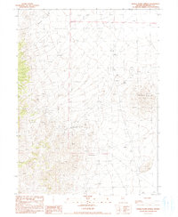
1990 Map of Donna Schee Spring
USGS Topo · Published 1990About this map
Donna Schee Spring and Noble Spring serve as critical water points in this arid expanse of Nevada's Humboldt County. The landscape is defined by the sharp relief of the Jungo Hills in the east and the course of Shawnee Creek to the northwest. This 1990 provisional survey records an environment shaped by small-scale mineral exploration and resource extraction, evidenced by numerous locations marked simply as Prospect and a larger Open Pit Mine.
Find a feature on this map
13 named features on this map. Tap any name to fly to it.
Don’t see what you’re looking for? This feature index may not catch every label — zoom into the map to look around manually.
Map Details
Editions of this 1990 Donna Schee Spring Map
This is the sole edition of this map. No revisions or reprints were ever made.
Other maps of this area

1886 · Disaster
USGS Topo · 1:250,000

1893 · Disaster
USGS Topo · 1:250,000

1931 · Lovelock
USGS Topo · 1:250,000

1935 · Lovelock
USGS Topo · 1:250,000

1954 · Vya
USGS Topo · 1:250,000

1955 · Lovelock
USGS Topo · 1:250,000

1958 · Vya
USGS Topo · 1:250,000

1959 · Lovelock
USGS Topo · 1:250,000

1962 · Vya
USGS Topo · 1:250,000

1966 · Donna Schee Peak
USGS Topo · 1:62,500