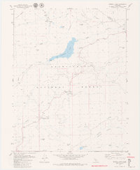
1979 Map of Donnell Lake
USGS Topo · Published 1979About this map
The Middle Fork Stanislaus River carves through the heart of the Stanislaus National Forest in this 1970s topographic study, defined by the prominent waters of Donnell Lake. The landscape reflects a mix of high-country recreation and seasonal grazing, evidenced by the presence of Wheats Cow Camp and several meadows such as Clover Meadow and Horse Meadow. Technical infrastructure is also present, notably the Intake Portal and the Herring Creek Reservoir to the south.
Find a feature on this map
36 named features on this map. Tap any name to fly to it.
Don’t see what you’re looking for? This feature index may not catch every label — zoom into the map to look around manually.
Map Details
Editions of this 1979 Donnell Lake Map
3 editions found
Other maps of this area

1891 · Big Trees
USGS Topo · 1:125,000

1894 · Big Trees
USGS Topo · 1:125,000

1896 · Dardanelles
USGS Topo · 1:125,000

1897 · Big Trees
USGS Topo · 1:125,000

1898 · Dardanelles
USGS Topo · 1:125,000

1901 · Big Trees
USGS Topo · 1:125,000

1947 · Sacramento
USGS Topo · 1:250,000

1948 · Walker Lake
USGS Topo · 1:250,000

1948 · Sacramento
USGS Topo · 1:250,000

1956 · Sacramento
USGS Topo · 1:250,000