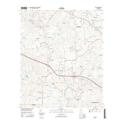
2014 Map of Dora
USGS Topo · Published 2014About this map
The industrial and riparian landscape of the Warrior Coal Basin is on full display where the Mulberry Fork and Locust Fork rivers define the terrain of Jefferson and Walker Counties. This 2014 survey captures a region deeply marked by its mining heritage, specifically shown in the expansive footprints of the Flat Top Mine Number 3 Impoundment and Bessie Mines Number 3 Impoundment. The map reveals a dense network of small communities such as Dora, Sumiton, and Quinton that grew around these extractive industries. Between the river bends, dozens of local landmarks provide critical data for genealogists and local historians, including the Shanghai Cemetery near Yerkwood and Bagley Bend Cemetery overlooking the river. Educational institutions like the Beville State Community College and essential infrastructure such as the West Jefferson Reservoir show the modern evolution of these historic settlements.
Find a feature on this map
171 named features on this map. Tap any name to fly to it.
Don’t see what you’re looking for? This feature index may not catch every label — zoom into the map to look around manually.
Map Details
Editions of this 2014 Dora Map
This is the sole edition of this map. No revisions or reprints were ever made.
Other maps of this area

1889 · Birmingham
USGS Topo · 1:125,000

1892 · Birmingham
USGS Topo · 1:125,000

1893 · Jasper
USGS Topo · 1:125,000

1895 · Birmingham
USGS Topo · 1:125,000

1904 · Birmingham Coal District
USGS Topo · 1:62,500

1906 · Birmingham Special
USGS Topo · 1:62,500

1907 · Birmingham
USGS Topo · 1:125,000

1935 · Port Birmingham
USGS Topo · 1:48,000

1938 · Port Birmingham
USGS Topo · 1:62,500

1949 · Cordova
USGS Topo · 1:24,000