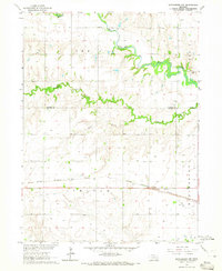
1964 Map of Dorchester NW
USGS Topo · Published 1965About this map
The West Fork Big Blue River snakes through the undulating farmland of the Seward and Saline county line, eventually joining the Big Blue River in the northeastern section of this 1964 survey. The landscape is defined by its drainage network, with Johnson Creek and Sand Creek carving through the prairie. Transport and industry follow the terrain, anchored by the Chicago Burlington and Quincy railroad line that cuts east-west across the southern portion of the quadrangle. Local genealogy is rooted in the presence of the Englehaupt Cem near the river fork and West Mills Cem further east, suggesting early clusters of rural settlement. A Gravel Pit and a Gaging Station on the river indicate the small-scale infrastructure and resource management common to the region during this era.
Find a feature on this map
14 named features on this map. Tap any name to fly to it.
Don’t see what you’re looking for? This feature index may not catch every label — zoom into the map to look around manually.
Map Details
Editions of this 1964 Dorchester NW Map
This is the sole edition of this map. No revisions or reprints were ever made.
Other maps of this area

1934 · Seward
USGS Topo · 1:48,000

1934 · Utica
USGS Topo · 1:62,500

1935 · Dorchester
USGS Topo · 1:48,000

1937 · Utica
USGS Topo · 1:62,500

1939 · Seward
USGS Topo · 1:62,500

1940 · Dorchester
USGS Topo · 1:62,500

1955 · Lincoln
USGS Topo · 1:250,000

1957 · Lincoln
USGS Topo · 1:250,000

1958 · Lincoln
USGS Topo · 1:250,000
1964 · Pleasant Hill
USGS Topo · 1:24,000