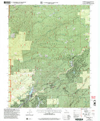
2001 Map of Dorrington
USGS Topo · Published 2004About this map
Calaveras Big Trees State Park anchors this portion of the Sierra Nevada, preserving the giant sequoia groves that have drawn travelers since the mid-19th century. The settlement of Dorrington and nearby Camp Connell sit along the historic corridor where early trans-Sierra routes once transitioned from the lower foothills into the high timber. To the south, the community of Arnold shows significant residential development through neighborhoods like Lilac Park, Lakeside Terrace, and Mumbert Acres, all clustered near the recreational waters of White Pines Lake.
Find a feature on this map
57 named features on this map. Tap any name to fly to it.
Don’t see what you’re looking for? This feature index may not catch every label — zoom into the map to look around manually.
Map Details
Editions of this 2001 Dorrington Map
This is the sole edition of this map. No revisions or reprints were ever made.
Other maps of this area

1891 · Big Trees
USGS Topo · 1:125,000

1894 · Big Trees
USGS Topo · 1:125,000

1897 · Big Trees
USGS Topo · 1:125,000

1901 · Big Trees
USGS Topo · 1:125,000

1947 · Sacramento
USGS Topo · 1:250,000

1948 · Sacramento
USGS Topo · 1:250,000

1948 · Columbia
USGS Topo · 1:62,500
1948 · Murphys
USGS Topo · 1:24,000

1948 · Stanislaus
USGS Topo · 1:24,000
1949 · Murphys
USGS Topo · 1:24,000