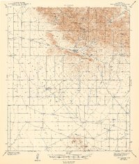
1943 Map of Dos Cabezas
USGS Topo · Published 1943About this map
Dos Cabezas anchors this wartime survey of the high desert and mountains of Cochise County. The landscape is defined by the intersection of early 20th-century mining and cattle ranching, where the northern peaks are marked by the Mascot Mine and Elma Mine. Settled holdings like the Arrowhead Ranch and SS Ranch stand out against the drainage networks of Ideal Draw and Cienega Draw, while the presence of Airway Beacon 4955 signals the area's importance to aviation in the early 1940s. The topography is dominated by the Sulphur Hills and prominent summits including Simmons Peak and Government Peak. Significant water sources such as Muskhog Spr and Apache Spr provided essential survival points in this arid environment, illustrating the sparse but vital infrastructure of the region prior to mid-century development.
Find a feature on this map
28 named features on this map. Tap any name to fly to it.
Don’t see what you’re looking for? This feature index may not catch every label — zoom into the map to look around manually.
Map Details
Editions of this 1943 Dos Cabezas Map
3 editions found

Other maps of this area

1916 · Pearce
USGS Topo · 1:125,000

1917 · San Simon
USGS Topo · 1:125,000

1917 · Chiricahua
USGS Topo · 1:125,000

1919 · Chiricahua
USGS Topo · 1:125,000

1922 · Willcox
USGS Topo · 1:125,000

1926 · Light
USGS Topo · 1:62,500

1926 · Cochise Head
USGS Topo · 1:62,500

1926 · Rucker
USGS Topo · 1:62,500

1926 · Courtland
USGS Topo · 1:62,500

1928 · Bowie
USGS Topo · 1:62,500