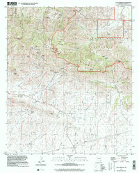
1996 Map of Dos Cabezas
USGS Topo · Published 2002About this map
The settlement of Dos Cabezas anchors this topographic study, situated at the base of the prominent Dos Cabezas Peaks within the larger Dos Cabezas Mountains. The landscape is a complex network of canyons and draws, reflecting a history of hard-rock mining and ranching in the high Arizona desert. Significant mining operations like the Mascot Mine and Gold Prince Mine are positioned along the slopes, while the local Cem and Rancho Sacatal provide evidence of long-term habitation. The northern half of the map is dominated by the Dos Cabezas Mountains Wilderness, where names like Happy Camp Canyon and Bota Chiquita Spring mark a terrain defined by its water sources. This 1996 update, based on imagery and earlier field surveys, captures the region as it transitioned toward conservation, preserved in the sprawling wilderness area surrounding Government Peak.
Find a feature on this map
51 named features on this map. Tap any name to fly to it.
Don’t see what you’re looking for? This feature index may not catch every label — zoom into the map to look around manually.
Map Details
Editions of this 1996 Dos Cabezas Map
This is the sole edition of this map. No revisions or reprints were ever made.
Other maps of this area

1917 · San Simon
USGS Topo · 1:125,000

1922 · Willcox
USGS Topo · 1:125,000

1926 · Cochise Head
USGS Topo · 1:62,500

1928 · Bowie
USGS Topo · 1:62,500

1943 · Dos Cabezas
USGS Topo · 1:62,500

1944 · Fisher Hills
USGS Topo · 1:62,500

1949 · Bowie
USGS Topo · 1:62,500

1950 · Bowie
USGS Topo · 1:62,500

1950 · Cochise Head
USGS Topo · 1:62,500

1954 · Silver City
USGS Topo · 1:250,000