
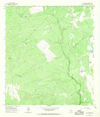
2010 Map of Dos Hermanos Peaks
USGS Topo · Published 2010About this map
Dos Hermanos Peaks rises as the primary landmark in this remote corner of Webb County, Texas. The landscape is defined by its ranching heritage, featuring established sites such as Puig Ranch, Apache Ranch, and Espada Ranch. Water management is central to the area's utility, evidenced by the Apache Ranch Lake Dam and the network of drainages that cross the brush country, including Espada Creek, Espita Creek, and Tierra Blanca Creek. While the terrain appears largely open, the intricate web of local roads connecting these ranching headquarters reveals a long-standing pattern of land use and livestock operations in the South Texas plains. In the southern reach of the map, Pinto Creek further illustrates the intermittent drainage systems that sustain this arid environment.
Find a feature on this map
9 named features on this map. Tap any name to fly to it.
Don’t see what you’re looking for? This feature index may not catch every label — zoom into the map to look around manually.
Map Details
Editions of this 2010 Dos Hermanos Peaks Map
This is the sole edition of this map. No revisions or reprints were ever made.
Other maps of this area

1923 · Palafox
USGS Topo · 1:62,500

1929 · Cotulla
USGS Topo · 1:125,000

1940 · Velenzuela Creek
USGS Topo · 1:62,500

1940 · San Loranzo Creek
USGS Topo · 1:62,500

1953 · Crystal City
USGS Topo · 1:250,000

1955 · Crystal City
USGS Topo · 1:250,000

1956 · Las Tiendas
USGS Topo · 1:62,500

1956 · Laredo
USGS Topo · 1:250,000

1961 · Crystal City
USGS Topo · 1:250,000
1965 · Las Tiendas
USGS Topo · 1:24,000