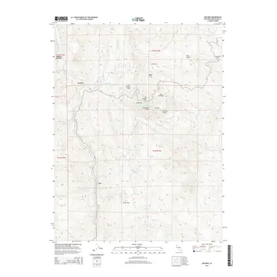
2015 Map of Dos Rios
USGS Topo · Published 2015About this map
The confluence of the Eel River and the Middle Fork Eel River defines this Mendocino County landscape, where the small settlement of Dos Rios sits at the water's meeting point. Further south along the banks of the main river, the community of Tatu is situated amidst a topography of steep canyons and high ridges. The map illustrates a high-elevation environment dominated by geographic landmarks like Big Chemise Knob and Hosea Ridge, alongside more remote high-country water features such as Howard Lake and Dead Cow Lake. The area's character is one of deep drainages, including Little Water Canyon and Big Water Canyon, highlighting the complex drainage network feeding into the Eel River system. To the northwest, the map identifies Indian Springs, while the eastern portion is marked by the distinctive Inspiration Point overlooking Kelly Canyon.
Find a feature on this map
45 named features on this map. Tap any name to fly to it.
Don’t see what you’re looking for? This feature index may not catch every label — zoom into the map to look around manually.
Map Details
Editions of this 2015 Dos Rios Map
This is the sole edition of this map. No revisions or reprints were ever made.
Other maps of this area

1920 · Covelo
USGS Topo · 1:62,500

1926 · Covelo
USGS Topo · 1:62,500

1929 · Eden Valley
USGS Topo · 1:62,500

1951 · Laytonville
USGS Topo · 1:62,500

1952 · Spyrock
USGS Topo · 1:62,500

1952 · Eden Valley
USGS Topo · 1:62,500

1952 · Covelo
USGS Topo · 1:62,500

1957 · Ukiah
USGS Topo · 1:250,000

1960 · Ukiah
USGS Topo · 1:250,000
1966 · Longvale
USGS Topo · 1:24,000