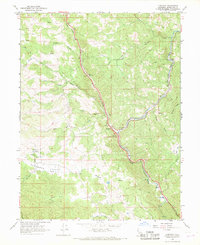
1966 Map of Longvale
USGS Topo · Published 1969About this map
Longvale serves as a central junction where the Northwestern Pacific railroad tracks and the winding path of 101 meet the waters of Long Valley Creek. In the late 1960s, this portion of Mendocino County remained a landscape of steep ridges and deep canyon drainages, defined by the convergence of Outlet Creek and the railroad corridor. The presence of the Sherwood Rancheria near Sherwood Valley and the small settlement at Graves highlights the historic human footprint in these uplands. Topographic details like Sam Watt Rock and Shimmin Ridge frame a territory where transportation was historically dictated by the narrow valley floors, while Moss Cove Rest Area and Irvine Rest Area mark the mid-century evolution of the highway as a primary artery for travelers through the Coast Range.
Find a feature on this map
26 named features on this map. Tap any name to fly to it.
Don’t see what you’re looking for? This feature index may not catch every label — zoom into the map to look around manually.
Map Details
Editions of this 1966 Longvale Map
2 editions found
Other maps of this area

1920 · Glenblair
USGS Topo · 1:62,500

1921 · Branscomb
USGS Topo · 1:62,500

1922 · Willits
USGS Topo · 1:62,500

1942 · Willits
USGS Topo · 1:62,500

1943 · Glenblair
USGS Topo · 1:62,500

1944 · Willits
USGS Topo · 1:62,500

1951 · Branscomb
USGS Topo · 1:62,500

1951 · Laytonville
USGS Topo · 1:62,500

1957 · Ukiah
USGS Topo · 1:250,000

1960 · Ukiah
USGS Topo · 1:250,000