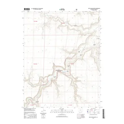
2016 Map of Doss Canyon North
USGS Topo · Published 2016About this map
Comanche National Grassland encompasses much of this southeastern Colorado landscape, defined by the deep incisions of the Purgatoire River as it carves through the High Plains. The river's path is marked by a series of dramatic bends and tributary systems, creating a complex network of canyons and arroyos. Major geological features like Purgatoire Canyon and Doss Canyon dominate the topography, while numerous smaller drainages such as Spring Canyon and Dead Horse Canyon branch off from the main channel. The map illustrates a largely unpopulated territory with very few road improvements, save for Co Rd 153 in the southeastern corner. This environment highlights the drainage patterns of the Lockwood Arroyo and Taylor Arroyo, revealing how water has shaped the terrain across the townships of T29S, T30S, and T31S.
Find a feature on this map
20 named features on this map. Tap any name to fly to it.
Don’t see what you’re looking for? This feature index may not catch every label — zoom into the map to look around manually.
Map Details
Editions of this 2016 Doss Canyon North Map
This is the sole edition of this map. No revisions or reprints were ever made.
Other maps of this area

1891 · Timpas
USGS Topo · 1:125,000

1891 · Mesa De Maya
USGS Topo · 1:125,000

1893 · Mesa de Maya
USGS Topo · 1:125,000

1894 · Timpas
USGS Topo · 1:125,000

1955 · La Junta
USGS Topo · 1:250,000

1958 · La Junta
USGS Topo · 1:250,000

1968 · La Junta
USGS Topo · 1:250,000

1972 · Johnson Canyon
USGS Topo · 1:24,000

1972 · Doss Canyon North
USGS Topo · 1:24,000

1972 · Doss Canyon South
USGS Topo · 1:24,000