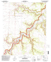
1996 Map of Doss Canyon North
USGS Topo · Published 2000About this map
The Purgatoire River carves a deep, winding path through this corner of Las Animas County, serving as the dominant geographic feature in an area defined by significant federal landholdings. In the mid-1990s, the northern portion of the quadrangle was largely occupied by the Fort Carson Military Reservation (Piñon Canyon Maneuver Site), while the central and southern reaches include sections of the Comanche National Grassland.
Find a feature on this map
16 named features on this map. Tap any name to fly to it.
Don’t see what you’re looking for? This feature index may not catch every label — zoom into the map to look around manually.
Map Details
Editions of this 1996 Doss Canyon North Map
This is the sole edition of this map. No revisions or reprints were ever made.
Other maps of this area

1891 · Timpas
USGS Topo · 1:125,000

1891 · Mesa De Maya
USGS Topo · 1:125,000

1893 · Mesa de Maya
USGS Topo · 1:125,000

1894 · Timpas
USGS Topo · 1:125,000

1955 · La Junta
USGS Topo · 1:250,000

1958 · La Junta
USGS Topo · 1:250,000

1968 · La Junta
USGS Topo · 1:250,000

1972 · Johnson Canyon
USGS Topo · 1:24,000

1972 · Doss Canyon North
USGS Topo · 1:24,000

1972 · Doss Canyon South
USGS Topo · 1:24,000