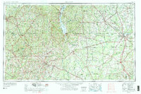
1953 Map of Dothan
USGS Topo · Published 1977About this map
The Chattahoochee River corridor serves as the central spine of this mid-century survey, dividing the Wiregrass region of Alabama from the agricultural plains of Southwest Georgia. In Alabama, the sprawling Fort Rucker Military Reservation stands as a massive landscape feature near Ozark and Enterprise, while the newly formed Walter F. George Reservoir alters the river's historic course near Eufaula. Across the state line, the Flint River winds toward Albany, a regional hub where the Georgia Normal and Agricultural College and Turner AFB are established.
Find a feature on this map
116 named features on this map. Tap any name to fly to it.
Don’t see what you’re looking for? This feature index may not catch every label — zoom into the map to look around manually.
Map Details
Editions of this 1953 Dothan Map
3 editions found

Other maps of this area

1942 · Enterprise
USGS Topo · 1:125,000

1948 · Ozark
USGS Topo · 1:62,500

1948 · Brundidge
USGS Topo · 1:62,500

1949 · Glendale
USGS Topo · 1:62,500

1949 · Hobbs Crossroads
USGS Topo · 1:24,000

1950 · Ozark
USGS Topo · 1:62,500

1950 · Hobbs Cross Roads
USGS Topo · 1:24,000

1950 · Enterprise
USGS Topo · 1:62,500

1950 · Izagora
USGS Topo · 1:24,000

1950 · Brundidge
USGS Topo · 1:62,500