1981 Map of Dothan
USGS Topo · Published 1982About this map
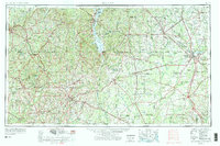
The Fort Rucker Military Reservation anchors this 1980s landscape, illustrating the significant federal footprint in Southeast Alabama. Surrounding this military hub, the region transitions into a well-defined network of agricultural and industrial towns, with Dothan serving as the primary commercial center. The map reveals the critical role of rail transport in the local economy, tracing routes like the Seaboard Coast Line and the Central of Georgia as they connect smaller communities like Midland City and Pinckard to larger markets. Hydrologically, the area is defined by the winding paths of the Choctawhatchee River and the Pea River, which have historically influenced settlement patterns and land use. From the western edge at Enterprise to the eastern border along the Chattahoochee River, the geography reflects a late-twentieth-century balance of military operations, established municipal centers, and the enduring importance of river and rail corridors.
Find a feature on this map
80 named features on this map. Tap any name to fly to it.
Don’t see what you’re looking for? This feature index may not catch every label — zoom into the map to look around manually.
Map Details
Editions of this 1981 Dothan Map
This is the sole edition of this map. No revisions or reprints were ever made.
Historical Maps of Dothan Through Time
4 maps found