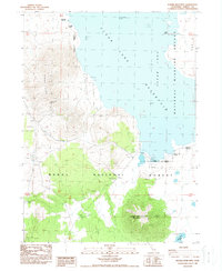
1988 Map of Double Head Mtn
USGS Topo · Published 1988About this map
Double Head Mountain and the surrounding high-desert terrain of Modoc County define this late 20th-century topographic study. The landscape is dominated by the expansive Clear Lake Reservoir, a critical water resource protected by the Clear Lake National Wildlife Refuge. This environment includes notable avian habitats like Bird Island, surrounded by the volcanic landforms of the Clear Lake Hills. To the south, the timbered slopes of the Modoc National Forest provide a sharp contrast to the open water and scrubland. Practical infrastructure is visible in the form of a Dike and a Corral, indicating the managed nature of this wilderness for both conservation and ranching. Smaller seasonal water bodies, including Harvey Lake and Double Head Lake, dot the depressions between the peaks, reflecting the complex drainage patterns of this northern California volcanic plateau.
Find a feature on this map
14 named features on this map. Tap any name to fly to it.
Don’t see what you’re looking for? This feature index may not catch every label — zoom into the map to look around manually.
Map Details
Editions of this 1988 Double Head Mtn Map
This is the sole edition of this map. No revisions or reprints were ever made.
Other maps of this area

1886 · Modoc Lava Bed
USGS Topo · 1:250,000

1892 · Modoc Lava-Bed
USGS Topo · 1:250,000

1951 · Clear Lake Reservoir
USGS Topo · 1:62,500

1951 · Tulelake
USGS Topo · 1:62,500

1952 · Timber Mountain
USGS Topo · 1:62,500

1952 · Hackamore
USGS Topo · 1:62,500

1954 · Alturas
USGS Topo · 1:250,000

1958 · Alturas
USGS Topo · 1:250,000

1962 · Alturas
USGS Topo · 1:250,000

1965 · Alturas
USGS Topo · 1:250,000