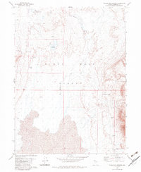
1979 Map of Double Hot Springs
USGS Topo · Published 1983About this map
Geothermal activity and desert hydrology define this portion of the Black Rock Desert in Humboldt County. The landscape is punctuated by numerous hydrothermal features, most notably the namesake Double Hot Springs and a series of Flowing Wells (Hot) that emerge across the basin floor. Human presence is sparse, centered on the remote Wheeler Ranch and the site of Hardin City, a namesake for the region's 19th-century silver mining lore.
Find a feature on this map
17 named features on this map. Tap any name to fly to it.
Don’t see what you’re looking for? This feature index may not catch every label — zoom into the map to look around manually.
Map Details
Editions of this 1979 Double Hot Springs Map
2 editions found
Other maps of this area

1886 · Disaster
USGS Topo · 1:250,000

1886 · Granite Range
USGS Topo · 1:250,000

1889 · Long Valley
USGS Topo · 1:250,000

1893 · Disaster
USGS Topo · 1:250,000

1894 · Granite Range
USGS Topo · 1:250,000

1931 · Lovelock
USGS Topo · 1:250,000

1935 · Lovelock
USGS Topo · 1:250,000

1954 · Vya
USGS Topo · 1:250,000

1955 · Lovelock
USGS Topo · 1:250,000

1958 · Vya
USGS Topo · 1:250,000