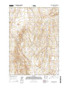
2014 Map of Double Mountain
USGS Topo · Published 2014About this map
Double Mountain rises as the dominant landmark in this Malheur County landscape, defined by an intricate network of desert water management. The area is marked by numerous engineered catchments such as the Upper Cow Reservoir, Lower Cow Reservoir, and Yellowjacket Reservoir, illustrating the critical role of water infrastructure in this arid region. Natural water sources like Bentonite Spring, Mud Spring, and the curiously named No Name Springs are scattered throughout the drainages, often linked by primitive routes like Twin Springs Rd. The presence of the Two Forks Creek Dam and various reservoirs suggest a landscape managed for livestock or irrigation. To the south, the terrain descends toward Cow Hollow and features prominent volcanic landmarks such as Shell Rock Butte.
Find a feature on this map
34 named features on this map. Tap any name to fly to it.
Don’t see what you’re looking for? This feature index may not catch every label — zoom into the map to look around manually.
Map Details
Editions of this 2014 Double Mountain Map
This is the sole edition of this map. No revisions or reprints were ever made.
Other maps of this area

1906 · Mitchell Butte
USGS Topo · 1:125,000

1955 · Boise
USGS Topo · 1:250,000

1958 · Boise
USGS Topo · 1:250,000

1962 · Boise
USGS Topo · 1:250,000
1967 · Vale East
USGS Topo · 1:24,000
1967 · Owyhee Dam
USGS Topo · 1:24,000
1967 · Vines Hill
USGS Topo · 1:24,000
1967 · Sourdough Spring
USGS Topo · 1:24,000
1967 · Kane Spring Gulch
USGS Topo · 1:24,000
1967 · Vale West
USGS Topo · 1:24,000