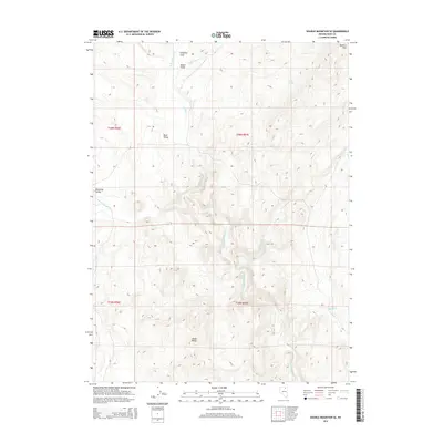
2014 Map of Double Mountain SE
USGS Topo · Published 2014About this map
The Adobe Range dominates this portion of Elko County, where high-desert drainage patterns define the land use. The N Fork Humboldt River carves through the central terrain, fed by numerous seasonal tributaries including Cottonwood Cr and Indian Cr. This 2014 survey documents a landscape primarily utilized for open-range ranching and grazing, as evidenced by named clearings like Coupling Field and Bassit Field near the headwaters of Beaver Cr. Local hydrology is marked by specific water sources such as Willow Spring and Warm Springs, which have long served as vital points in this arid environment. The map also captures the distinct transitions between the elevated Mallard Hills and the lower reaches of Willmings Valley and Bone Valley, providing a detailed record of the physical geography before contemporary changes.
Find a feature on this map
19 named features on this map. Tap any name to fly to it.
Don’t see what you’re looking for? This feature index may not catch every label — zoom into the map to look around manually.
Map Details
Editions of this 2014 Double Mountain SE Map
This is the sole edition of this map. No revisions or reprints were ever made.
Other maps of this area

1955 · Wells
USGS Topo · 1:250,000

1958 · Wells
USGS Topo · 1:250,000

1961 · Wells
USGS Topo · 1:250,000

1967 · Hanks Creek SW
USGS Topo · 1:24,000

1967 · Stag Mountain
USGS Topo · 1:24,000

1967 · Peko Peak
USGS Topo · 1:24,000

1971 · Double Mtn
USGS Topo · 1:24,000

1971 · Devils Armchair
USGS Topo · 1:24,000
1971 · Coal Mine Basin
USGS Topo · 1:24,000

1971 · Double Mtn SE
USGS Topo · 1:24,000