
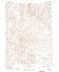
1971 Map of Double Mtn
USGS Topo · Published 1974About this map
High desert ranching and water rights define this 1971 survey of the northern Independence Mountains. The landscape is dominated by the volcanic mass of Double Mtn, with a network of Jeep Trail routes providing access to remote stock-watering points. The mapping identifies numerous named water sources critical to the high-country range, including Chicken Creek Springs, Wagon Box Spring, and the Double Mtn Well. The Brown House stands as a solitary named structure in the northeast, positioned along the headwaters of West Fork Beaver Creek. The density of named springs and canyons like Dorsey Canyon and Water Canyon suggests a landscape managed for cattle and seasonal grazing, where specific water locations served as vital landmarks for buckaroos and ranchers in the Elko County backcountry.
Find a feature on this map
21 named features on this map. Tap any name to fly to it.
Don’t see what you’re looking for? This feature index may not catch every label — zoom into the map to look around manually.
Map Details
Editions of this 1971 Double Mtn Map
2 editions found
Other maps of this area

1935 · Charleston
USGS Topo · 1:48,000

1942 · Mt. Velma
USGS Topo · 1:62,500

1955 · Wells
USGS Topo · 1:250,000

1956 · Wild Horse
USGS Topo · 1:62,500

1958 · Wells
USGS Topo · 1:250,000

1961 · Wells
USGS Topo · 1:250,000

1971 · Devils Armchair
USGS Topo · 1:24,000

1971 · North Fork
USGS Topo · 1:24,000

1971 · Double Mtn SE
USGS Topo · 1:24,000
1971 · Mahala Creek East
USGS Topo · 1:24,000