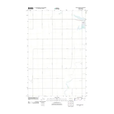
2011 Map of Douglas West
USGS Topo · Published 2011About this map
Douglas sits in the northeast corner of this agricultural landscape, centered at the intersection of Main St N and 142nd St SW. The surrounding countryside in Ward County is defined by a strictly organized grid of rural roads, including 373rd Ave SW and 45th Ave NW, which partition the prairie into large sections. Hydrological features provide the primary variation in the terrain, most notably Douglas Lake just south of the town site and the winding path of the Middle Branch Douglas Creek which meanders through the southern half of the quadrangle. This 2011 edition, produced by the U.S. Geological Survey, reflects the persistent rural character of the region, where the infrastructure is built almost entirely around the movement of goods and people across the vast North Dakota plains.
Find a feature on this map
23 named features on this map. Tap any name to fly to it.
Don’t see what you’re looking for? This feature index may not catch every label — zoom into the map to look around manually.
Map Details
Editions of this 2011 Douglas West Map
This is the sole edition of this map. No revisions or reprints were ever made.
Other maps of this area

1922 · Garrison
USGS Topo · 1:62,500

1954 · McClusky
USGS Topo · 1:250,000

1956 · Emmet NE
USGS Topo · 1:24,000

1956 · Blue Hill
USGS Topo · 1:24,000

1956 · Emmet
USGS Topo · 1:24,000

1956 · Douglas West
USGS Topo · 1:24,000

1958 · McClusky
USGS Topo · 1:250,000
1974 · Garrison NW
USGS Topo · 1:24,000

1980 · Lake Vernon
USGS Topo · 1:24,000
1980 · Douglas East
USGS Topo · 1:24,000