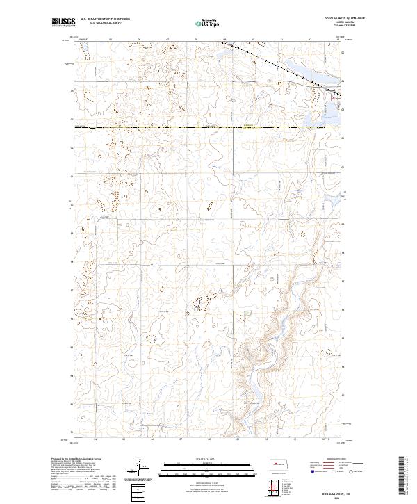
2024 Map of Douglas West
USGS Topo · Published 2024About this map
Douglas occupies the northeast corner of this map, serving as a hub for the surrounding agricultural prairie on the border of Ward and McLean counties. The landscape is characterized by the prairie pothole region's distinctive hydrology, featuring numerous small wetlands and the larger Bartons Lake. Preservation of this habitat is evident in the Ward County Waterfowl Production Area, which spans several sections in the north. The terrain is further defined by the drainage of Middle Branch Douglas Creek, which meanders through the southeast. A strictly gridded network of section-line roads, including Co Hwy 11 and McLean Co Hwy 2, provides access to the expansive farmsteads that have defined this part of the North Dakota plains for generations.
Find a feature on this map
31 named features on this map. Tap any name to fly to it.
Don’t see what you’re looking for? This feature index may not catch every label — zoom into the map to look around manually.
Map Details
Editions of this 2024 Douglas West Map
This is the sole edition of this map. No revisions or reprints were ever made.
Other maps of this area

1922 · Garrison
USGS Topo · 1:62,500

1954 · McClusky
USGS Topo · 1:250,000

1956 · Emmet NE
USGS Topo · 1:24,000

1956 · Blue Hill
USGS Topo · 1:24,000

1956 · Emmet
USGS Topo · 1:24,000

1956 · Douglas West
USGS Topo · 1:24,000

1958 · McClusky
USGS Topo · 1:250,000
1974 · Garrison NW
USGS Topo · 1:24,000

1980 · Lake Vernon
USGS Topo · 1:24,000
1980 · Douglas East
USGS Topo · 1:24,000