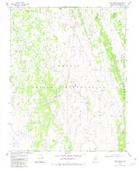
1982 Map of Dove Spring
USGS Topo · Published 1983About this map
The Navajo Indian Reservation landscape is defined by the high elevations of Little Black Mesa and Mormon Ridge in this early 1980s topography. The area is characterized by scattered ranching and water infrastructure, including a Chapter House and several livestock or water facilities like the Dove Spring Well. The map captures a moment when resource exploration is evident through features such as the Copper Mine Well (Dry) and a Prospect site, reflecting the region's mineral potential. Topographic landmarks like Hole in Rock provide natural orientation points amidst the complex system of washes and ridges. This survey illustrates the vital importance of groundwater in the high desert, documenting a network of remote wells including Well No 3 and the Kai-Si-Kad Well No 1, which supported both local residents and grazing livestock within the reservation boundaries.
Find a feature on this map
16 named features on this map. Tap any name to fly to it.
Don’t see what you’re looking for? This feature index may not catch every label — zoom into the map to look around manually.
Map Details
Editions of this 1982 Dove Spring Map
This is the sole edition of this map. No revisions or reprints were ever made.
Other maps of this area

1886 · Echo Cliffs
USGS Topo · 1:250,000

1891 · Echo Cliffs
USGS Topo · 1:250,000

1954 · Shinumo Altar NE
USGS Topo · 1:24,000

1954 · Tanner Wash
USGS Topo · 1:62,500

1954 · Shinumo Altar
USGS Topo · 1:62,500

1955 · Tanner Wash NE
USGS Topo · 1:24,000

1956 · Marble Canyon
USGS Topo · 1:250,000

1959 · Marble Canyon
USGS Topo · 1:250,000

1961 · Marble Canyon
USGS Topo · 1:250,000
1982 · Toh Bih Nosteny
USGS Topo · 1:24,000