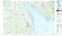
1984 Map of Dover
USGS Topo · Published 1985About this map
Dover and the mid-Delaware region are documented here in the mid-1980s, showcasing the intricate relationship between the coastal wetlands and inland agricultural settlements. The landscape is defined by the Delaware Bay and a network of tidal rivers including the St Jones River and Murderkill River. Significant conservation efforts are visible through the extensive Bombay Hook National Wildlife Refuge and numerous management areas like Egg Island Wildlife Management Area on the New Jersey shore.
Find a feature on this map
150 named features on this map. Tap any name to fly to it.
Don’t see what you’re looking for? This feature index may not catch every label — zoom into the map to look around manually.
Map Details
Editions of this 1984 Dover Map
This is the sole edition of this map. No revisions or reprints were ever made.
Other maps of this area

1888 · Cape May
USGS Topo · 1:62,500

1888 · Dennisville
USGS Topo · 1:62,500

1890 · Hammonton
USGS Topo · 1:62,500

1890 · Salem
USGS Topo · 1:62,500

1890 · Tuckahoe
USGS Topo · 1:62,500

1890 · Maurice Cove
USGS Topo · 1:62,500

1890 · Bay Side
USGS Topo · 1:62,500

1890 · Bridgeton
USGS Topo · 1:62,500

1890 · Glassboro
USGS Topo · 1:62,500

1891 · Maurice Cove
USGS Topo · 1:62,500