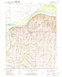
1950 Map of Dover
USGS Topo · Published 1979About this map
The Missouri River defines the northern edge of this Lafayette County landscape, where the fertile bottoms of Cherry Valley and Baltimore Island meet the rising river bluffs. Settlement here was historically driven by the dual influence of the water and the Missouri Pacific railroad, which skirts the base of the hills through Dover Station and Hodge. The interior of Dover township is marked by a network of drainage systems including Little Tabo Creek and Cottonwood Creek, which carve the terrain into a series of ridges and hollows.
Find a feature on this map
18 named features on this map. Tap any name to fly to it.
Don’t see what you’re looking for? This feature index may not catch every label — zoom into the map to look around manually.
Map Details
Editions of this 1950 Dover Map
2 editions found
Other maps of this area

1889 · Lexington
USGS Topo · 1:125,000

1949 · Mayview
USGS Topo · 1:24,000

1949 · Lexington East
USGS Topo · 1:24,000

1950 · Lexington East
USGS Topo · 1:24,000

1950 · Mayview
USGS Topo · 1:24,000

1950 · Dover
USGS Topo · 1:24,000
1951 · Dover
USGS Topo · 1:24,000

1951 · Alma
USGS Topo · 1:24,000
1951 · Higginsville
USGS Topo · 1:24,000

1951 · Waverly
USGS Topo · 1:24,000