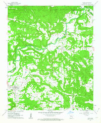
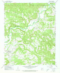
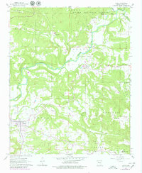
1961 Map of Dover
USGS Topo · Published 1963About this map
Illinois Bayou and its winding tributaries like Little Creek and McCoy Creek define the landscape of this Pope County region in the early 1960s. The settlement of Dover serves as a local hub, featuring its High Sch and nearby family burial grounds such as McFadden Cem and Lake Cem. Further north, the village of Scottsville sits near the banks of the bayou, surrounded by a network of rural churches including Cedar Grove Ch and Newton Springs Ch.
Find a feature on this map
32 named features on this map. Tap any name to fly to it.
Don’t see what you’re looking for? This feature index may not catch every label — zoom into the map to look around manually.
Map Details
Editions of this 1961 Dover Map
3 editions found
Other maps of this area

1879 · Washington
USGS Topo · 1:62,500

1887 · Smyrna
USGS Topo · 1:62,500

1888 · Dardanelle #1
USGS Topo · 1:62,500

1889 · Treat
USGS Topo · 1:62,500

1889 · Marshall #3
USGS Topo · 1:62,500

1890 · Dardanelle
USGS Topo · 1:125,000

1892 · Marshall
USGS Topo · 1:125,000

1892 · Morrillton
USGS Topo · 1:125,000

1894 · Morrillton
USGS Topo · 1:125,000

1894 · Marshall
USGS Topo · 1:125,000