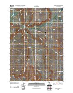
2011 Map of Downey Canyon
USGS Topo · Published 2011About this map
High desert ranching and water management define this corner of Malheur County, where the landscape is organized around intermittent creeks and a network of small reservoirs. Scott Ranch and Glover Ranch represent the human footprint in this arid environment, strategically positioned near the drainage systems of Cow Creek and Downey Creek. The topography is marked by significant features like Table Mountain and Big Ridge, which overlook deep incisions in the earth such as Downey Canyon and Box Canyon.
Find a feature on this map
33 named features on this map. Tap any name to fly to it.
Don’t see what you’re looking for? This feature index may not catch every label — zoom into the map to look around manually.
Map Details
Editions of this 2011 Downey Canyon Map
This is the sole edition of this map. No revisions or reprints were ever made.
Other maps of this area

1955 · Jordan Valley
USGS Topo · 1:250,000

1955 · Boise
USGS Topo · 1:250,000

1957 · Jordan Valley
USGS Topo · 1:250,000

1958 · Boise
USGS Topo · 1:250,000

1958 · Jordan Valley
USGS Topo · 1:250,000

1962 · Boise
USGS Topo · 1:250,000
1969 · Mahogany Gap
USGS Topo · 1:24,000

1969 · Mc Cain Creek
USGS Topo · 1:24,000
1969 · Hooker Creek
USGS Topo · 1:24,000

1969 · Cow Lakes
USGS Topo · 1:24,000