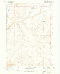
1969 Map of Downey Canyon
USGS Topo · Published 1973About this map
Table Mountain dominates the northern horizon of this remote Malheur County landscape, where water management defines the high-desert terrain. By the late 1960s, a complex system of livestock-watering infrastructure was established across the canyons, including Carter Reservoir, Tableland Reservoir, and the more distant Goodyear Reservoir. The mapping reveals how ranching and resource extraction shaped the land, evidenced by the Cowgill Well and scattered Borrow Pits near the confluence of Cow Creek and Downey Creek. A lonely Landing Strip and numerous Jeep Trails provide the only access through the drainage systems of Downey Canyon and Box Canyon, reflecting a period of intensive land management in Oregon's southeastern corner. This survey is particularly useful for identifying named water sources like Downey Canyon Spring and Fells Spring that have long sustained life in this arid volcanic region.
Find a feature on this map
30 named features on this map. Tap any name to fly to it.
Don’t see what you’re looking for? This feature index may not catch every label — zoom into the map to look around manually.
Map Details
Editions of this 1969 Downey Canyon Map
This is the sole edition of this map. No revisions or reprints were ever made.
Other maps of this area

1955 · Jordan Valley
USGS Topo · 1:250,000

1955 · Boise
USGS Topo · 1:250,000

1957 · Jordan Valley
USGS Topo · 1:250,000

1958 · Boise
USGS Topo · 1:250,000

1958 · Jordan Valley
USGS Topo · 1:250,000

1962 · Boise
USGS Topo · 1:250,000
1969 · Mahogany Gap
USGS Topo · 1:24,000

1969 · Mc Cain Creek
USGS Topo · 1:24,000
1969 · Hooker Creek
USGS Topo · 1:24,000

1969 · Cow Lakes
USGS Topo · 1:24,000