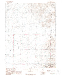
1988 Map of Downeyville
USGS Topo · Published 1988About this map
Downeyville sits at the base of the Lodi Hills, marking a significant location for historical research in this corner of Nye County. The map details a transition from the industrial activity of the Sierra Magnesite Camp and the Victory Mine to the open expanse of Gabbs Valley. The presence of the Gabbs Airport and its associated beacon suggests the area's role in local aviation and transit, while a desert Golf Course and several water sources like Holly Well indicate the specific infrastructure required to support life in this arid environment.
Find a feature on this map
22 named features on this map. Tap any name to fly to it.
Don’t see what you’re looking for? This feature index may not catch every label — zoom into the map to look around manually.
Map Details
Editions of this 1988 Downeyville Map
This is the sole edition of this map. No revisions or reprints were ever made.
Other maps of this area

1907 · Tonopah
USGS Topo · 1:250,000

1908 · Tonopah
USGS Topo · 1:250,000

1908 · Carson Sink
USGS Topo · 1:250,000

1909 · Hawthorne
USGS Topo · 1:250,000

1910 · Carson Sink
USGS Topo · 1:250,000

1911 · Hawthorne
USGS Topo · 1:250,000

1915 · Hawthorne
USGS Topo · 1:250,000

1948 · Paradise Peak
USGS Topo · 1:62,500

1948 · Walker Lake
USGS Topo · 1:250,000

1950 · Paradise Peak
USGS Topo · 1:62,500