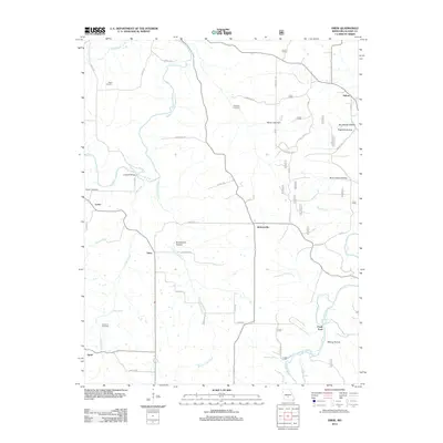
2012 Map of Drew
USGS Topo · Published 2012About this map
Gasconade River and its winding tributary, the Osage Fork Gasconade River, define the rural landscape of Missouri-Laclede County in this early 21st-century survey. The terrain is marked by numerous hollows, including Big Sleepy Hollow and Burnt Cabin Hollow, which suggest a long history of local naming conventions tied to the timbered ridges and valleys. Small settlements like Drew, Jacksonville, and Falcon are connected by a network of backroads such as Bobcat RD and Vintage RD, while the area's agricultural and social foundations are evidenced by family-named landmarks like Heard Cemetery, Hamilton Cemetery, and Bohanon Cemetery. Further downstream, Clark Ford and the Lambeth Bridge provide essential crossings over the complex waterway system, which is also punctuated by natural features like Blue Spring and Mayfield Spring, as well as the man-made Morris Lake Dam.
Find a feature on this map
45 named features on this map. Tap any name to fly to it.
Don’t see what you’re looking for? This feature index may not catch every label — zoom into the map to look around manually.
Map Details
Editions of this 2012 Drew Map
This is the sole edition of this map. No revisions or reprints were ever made.
Other maps of this area

1931 · Manes
USGS Topo · 1:48,000

1941 · Manes
USGS Topo · 1:62,500

1941 · Lebanon
USGS Topo · 1:62,500

1943 · Lebanon
USGS Topo · 1:62,500

1943 · Manes
USGS Topo · 1:62,500

1943 · Drynob
USGS Topo · 1:62,500

1954 · Springfield
USGS Topo · 1:250,000

1954 · Drynob
USGS Topo · 1:62,500

1954 · Drew
USGS Topo · 1:24,000
1954 · Winnipeg
USGS Topo · 1:24,000