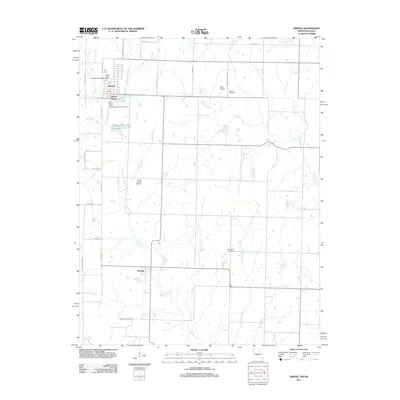
2011 Map of Drexel
USGS Topo · Published 2011About this map
Drexel and the community of South Drexel straddle the Missouri-Kansas border, anchored by the north-south artery of State Line Rd. This 2011 survey captures a landscape defined by its hydrology, where agricultural land is partitioned by the winding courses of Mormon Fork, Miami Creek, and North Sugar Creek. Local infrastructure is visible through the Drexel City Reservoir South and the Drexel Lake complex, which serve the town's immediate vicinity. To the south, the village of Merwin sits near the confluence of several small branches. For those tracing local heritage, the map identifies several rural burial grounds, including West Point Cemetery on the western edge and Edgewood Cemetery to the east. The presence of private airstrips like May Airport and Arvin Ranch Airport suggests the continued importance of aviation in this borderland corridor between Cass and Bates counties.
Find a feature on this map
32 named features on this map. Tap any name to fly to it.
Don’t see what you’re looking for? This feature index may not catch every label — zoom into the map to look around manually.
Map Details
Editions of this 2011 Drexel Map
This is the sole edition of this map. No revisions or reprints were ever made.
Other maps of this area

1887 · Harrisonville
USGS Topo · 1:125,000

1887 · Olathe
USGS Topo · 1:125,000

1887 · Butler
USGS Topo · 1:125,000

1887 · Mound City
USGS Topo · 1:125,000

1892 · Harrisonville
USGS Topo · 1:125,000

1893 · Mound City
USGS Topo · 1:125,000

1893 · Olathe
USGS Topo · 1:125,000

1894 · Harrisonville
USGS Topo · 1:125,000

1894 · Butler
USGS Topo · 1:125,000

1947 · Lawrence
USGS Topo · 1:250,000