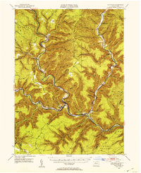
1945 Map of Driftwood
USGS Topo · Published 1953About this map
Driftwood Branch Sinnemahoning Creek and Bennett Branch Sinnemahoning Creek converge at the town of Driftwood, forming a natural transportation hub at the heart of the Pennsylvania Wilds. This mid-century survey reveals a landscape defined by the Pennsylvania railroad lines that follow the tight river valleys, connecting small settlements like Sterling Run and Sinnemahoning. The map documents the scattered rural infrastructure that supported these valley communities, including the First Fork Sch, Grove Hill Ch, and numerous family-named burial grounds such as Gilmore Cem and Smith Cem. Higher elevations like Mason Hill and Huston Hill overlook a network of tributary runs and hollows, while industrial markers like a Stone Quarry and the Slyder Airport indicate the diverse economy of Cameron County during the post-war era.
Find a feature on this map
99 named features on this map. Tap any name to fly to it.
Don’t see what you’re looking for? This feature index may not catch every label — zoom into the map to look around manually.
Map Details
Editions of this 1945 Driftwood Map
4 editions found
Other maps of this area

1928 · Snow Shoe
USGS Topo · 1:48,000

1929 · Karthaus
USGS Topo · 1:62,500

1929 · Clearfield
USGS Topo · 1:48,000

1931 · Show Shoe
USGS Topo · 1:62,500

1932 · Clearfield
USGS Topo · 1:62,500

1932 · Karthaus
USGS Topo · 1:62,500

1941 · Benezette
USGS Topo · 1:62,500

1943 · Benezette
USGS Topo · 1:62,500

1945 · Driftwood
USGS Topo · 1:48,000

1945 · First Fork
USGS Topo · 1:24,000
Featured Places
- Benezette Township, PA
- Wharton Township, PA
- Driftwood, PA
- Lushbaugh, Grove Township
- Cameron, Lumber Township