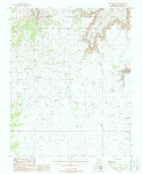
1988 Map of Driftwood Canyon
USGS Topo · Published 1988About this map
Havasupai Indian Reservation land dominates the northern portion of this Coconino County terrain, characterized by the deep incisions of Hualapai Canyon and Driftwood Canyon. This 1988 provisional survey provides a precise look at a landscape defined by its scarce water resources and dramatic verticality. The reliance on localized water catchments is evident in the naming of features such as Twin Tanks and Kaufman Tanks, which served as vital points in an arid environment. To the southeast, the topography descends into Disquiba Canyon and follows the course of Twin Tank Draw. The map is a study of isolation and elevation, showing the intricate network of trails and unimproved roads that navigate the plateau above the canyons, reflecting the geographic reality of this part of the Colorado Plateau in the late 1980s.
Find a feature on this map
12 named features on this map. Tap any name to fly to it.
Don’t see what you’re looking for? This feature index may not catch every label — zoom into the map to look around manually.
Map Details
Editions of this 1988 Driftwood Canyon Map
This is the sole edition of this map. No revisions or reprints were ever made.
Other maps of this area

1886 · Chino
USGS Topo · 1:250,000

1886 · Kaibab
USGS Topo · 1:250,000

1891 · Chino
USGS Topo · 1:250,000

1948 · Williams
USGS Topo · 1:250,000

1953 · Grand Canyon
USGS Topo · 1:250,000

1954 · Williams
USGS Topo · 1:250,000

1956 · Williams
USGS Topo · 1:250,000

1957 · Grand Canyon
USGS Topo · 1:250,000

1958 · Grand Canyon
USGS Topo · 1:250,000

1960 · Williams
USGS Topo · 1:250,000