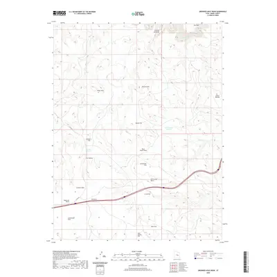
2020 Map of Drowned Hole Draw
USGS Topo · Published 2020About this map
The San Rafael River cuts through the northern reaches of this Emery County landscape, where the dramatic Black Box canyon formation dominates the northeastern corner. This modern survey illustrates a rugged arid geography defined by expansive flats and elevated benches, many bearing the names of early travelers or local fauna. Water management is a central theme in this environment, evidenced by the Black Dragon Reservoir and Sinkhole Reservoir, which capture runoff in an area otherwise drained by intermittent systems like Black Dragon Wash and Drowned Hole Draw. Interstate 70 serves as the primary modern artery, crossing the southern half of the map near Jerrys Flat and Sagebrush Bench. Local history and geology converge at locations like The Sinkhole and Cliff Dweller Flat, reflecting both the natural erosive forces and the human memory attached to this part of the San Rafael Swell.
Find a feature on this map
22 named features on this map. Tap any name to fly to it.
Don’t see what you’re looking for? This feature index may not catch every label — zoom into the map to look around manually.
Map Details
Editions of this 2020 Drowned Hole Draw Map
This is the sole edition of this map. No revisions or reprints were ever made.
Other maps of this area

1885 · San Rafael
USGS Topo · 1:250,000

1886 · Price River
USGS Topo · 1:250,000

1896 · Price River
USGS Topo · 1:250,000

1953 · Red Plateau SE
USGS Topo · 1:24,000

1953 · Tidwell 2 SW
USGS Topo · 1:24,000

1953 · Red Plateau SW
USGS Topo · 1:24,000

1953 · Beckwith Peak SW
USGS Topo · 1:24,000

1953 · Tidwell 2 NW
USGS Topo · 1:24,000

1954 · Stinking Spring Creek 1 SE
USGS Topo · 1:24,000

1954 · Stinking Spring Creek 1 NW
USGS Topo · 1:24,000