
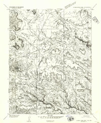
1954 Map of Stinking Spring Creek 1 SE
USGS Topo · Published 1954About this map
Cliff Dwellers Flat and the expansive terrain known as Sinbad dominate this mid-century preliminary survey of the Utah backcountry. The landscape is defined by intricate drainage systems including Red Draw, Hyde Draw, and Greasewood Draw, which cut through the high plateaus. A particularly curious local landmark, Arsons Gardens, appears in the northeastern quadrant, suggesting a pocket of human activity or a distinct ecological niche amidst the arid draws and flats. The topography, mapped via multiplex methods from early 1950s aerial photography, captures the raw physical geography of Country before significant modern development altered these remote stretches of Emery County.
Find a feature on this map
10 named features on this map. Tap any name to fly to it.
Don’t see what you’re looking for? This feature index may not catch every label — zoom into the map to look around manually.
Map Details
Editions of this 1954 Stinking Spring Creek 1 SE Map
This is the sole edition of this map. No revisions or reprints were ever made.
Other maps of this area

1885 · San Rafael
USGS Topo · 1:250,000

1953 · Tidwell 2 SW
USGS Topo · 1:24,000

1953 · Tidwell 3 NW
USGS Topo · 1:24,000

1953 · Tidwell 2 NW
USGS Topo · 1:24,000

1953 · Temple Mtn
USGS Topo · 1:62,500

1954 · Stinking Spring Creek 1 NW
USGS Topo · 1:24,000

1954 · Stinking Spring Creek 4 NE
USGS Topo · 1:24,000

1954 · Stinking Spring Creek 4 NW
USGS Topo · 1:24,000

1954 · Stinking Spring Creek 1 NE
USGS Topo · 1:24,000
1954 · Stinking Spring Creek 1 SW
USGS Topo · 1:24,000