
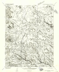
1954 Map of Stinking Spring Creek 4 NE
USGS Topo · Published 1954About this map
San Rafael Desert dominates the landscape in this mid-century preliminary study, where drainage patterns and water sources dictated the rhythm of movement through the arid terrain. The complex topography is marked by deeply incised features like Ernie Canyon and the notable Iron Woman formation. Water, the most critical resource for early explorers and ranchers, is meticulously documented at sites such as Morman Tanks and Swazy Seep. Several dry channels, including Temple Wash, Iron Wash, and Old Woman Wash, carve paths toward the east, illustrating the erosion-heavy character of the region. These intermittent washes and isolated springs like Lost Spring and Temple Spring served as essential landmarks for navigation across the open desert flats and benchlands of Emery County before the era of modern development.
Find a feature on this map
11 named features on this map. Tap any name to fly to it.
Don’t see what you’re looking for? This feature index may not catch every label — zoom into the map to look around manually.
Map Details
Editions of this 1954 Stinking Spring Creek 4 NE Map
This is the sole edition of this map. No revisions or reprints were ever made.
Other maps of this area

1885 · San Rafael
USGS Topo · 1:250,000

1953 · Tidwell 2 SW
USGS Topo · 1:24,000

1953 · Tidwell 3 NW
USGS Topo · 1:24,000

1953 · Temple Mtn
USGS Topo · 1:62,500

1954 · Stinking Springs Creek 4 SW
USGS Topo · 1:24,000

1954 · Stinking Spring Creek 1 SE
USGS Topo · 1:24,000

1954 · Stinking Spring Creek 4 NW
USGS Topo · 1:24,000

1954 · Stinking Spring Creek 4 SE
USGS Topo · 1:24,000
1954 · Stinking Spring Creek 1 SW
USGS Topo · 1:24,000

1954 · Tidwell Bottoms
USGS Topo · 1:62,500