
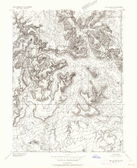
1953 Map of Red Plateau SW
USGS Topo · Published 1954About this map
San Rafael River carves through the heart of this Central Utah landscape, defining a region of intense geologic relief within the Swell. The 1952 aerial surveys captured a terrain dominated by massive formations such as Bottleneck Peak, Window Blind Peak, and the cathedral-like Assembly Hall. This preliminary edition map preserves the early industrial footprint of the era, specifically recording Oil Well Test Holes (Aban) that mark mid-century petroleum exploration efforts on the plateau. Drainage patterns are meticulously detailed through Buckhorn Wash and Cane Wash, illustrating the complex hydrology of the Limestone Bench and the high promontory of The Wedge. Isolated water sources, including a named Well and Seep, provide critical landmarks in a desert environment where topography dictated movement and resource access.
Find a feature on this map
14 named features on this map. Tap any name to fly to it.
Don’t see what you’re looking for? This feature index may not catch every label — zoom into the map to look around manually.
Map Details
Editions of this 1953 Red Plateau SW Map
2 editions found
Other maps of this area

1885 · San Rafael
USGS Topo · 1:250,000

1886 · Price River
USGS Topo · 1:250,000

1896 · Price River
USGS Topo · 1:250,000

1952 · San Rafael Knob
USGS Topo · 1:62,500

1953 · Wilsonville SE
USGS Topo · 1:24,000

1953 · Red Plateau SE
USGS Topo · 1:24,000

1954 · Stinking Spring Creek 1 NW
USGS Topo · 1:24,000

1954 · Stinking Spring Creek 1 NE
USGS Topo · 1:24,000

1954 · Stinking Spring Creek 2 NE
USGS Topo · 1:24,000
1954 · Wilsonville SE
USGS Topo · 1:24,000