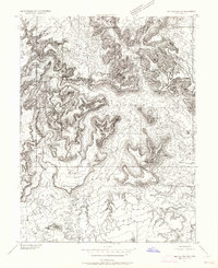
1953 Map of Red Plateau SW
USGS Topo · Published 1964About this map
San Rafael River carves a deep, sinuous path through this 1953 survey of Emery County, Utah. The landscape is dominated by the dramatic uplift of the San Rafael Swell, featuring prominent natural landmarks like Bottleneck Peak, Assembly Hall, and the towering Window Blind Peak. This preliminary edition map details a complex network of canyons and plateaus, including The Wedge and Prickly Pear Flat, illustrating the natural barriers that shaped movement through the region before modern infrastructure was fully established.
Find a feature on this map
16 named features on this map. Tap any name to fly to it.
Don’t see what you’re looking for? This feature index may not catch every label — zoom into the map to look around manually.
Map Details
Editions of this 1953 Red Plateau SW Map
2 editions found
Other maps of this area

1885 · San Rafael
USGS Topo · 1:250,000

1886 · Price River
USGS Topo · 1:250,000

1896 · Price River
USGS Topo · 1:250,000

1952 · San Rafael Knob
USGS Topo · 1:62,500

1953 · Wilsonville SE
USGS Topo · 1:24,000

1953 · Red Plateau SE
USGS Topo · 1:24,000

1953 · Red Plateau SW
USGS Topo · 1:24,000

1954 · Stinking Spring Creek 1 NW
USGS Topo · 1:24,000

1954 · Stinking Spring Creek 1 NE
USGS Topo · 1:24,000

1954 · Stinking Spring Creek 2 NE
USGS Topo · 1:24,000