1892 Map of Drum Point
USGS Topo · Published 1896About this map
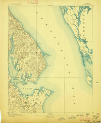
The tidal landscape of the Chesapeake Bay dominates this late nineteenth-century survey, centering on the strategically positioned Drum Point and the adjacent waters of the Patuxent River. Detailed topography reveals a network of small coastal settlements such as Lusby, St. Leonard, and Solomon I., established along the high ground between deeply incised estuaries. The map captures the complex shoreline of Calvert, St Mary, and Dorchester counties before modern development altered these traditional maritime corridors. Notable maritime landmarks include the Drum Point lighthouse and the distinct points of land like Cedar Point and Cove Point. The survey traces numerous small waterways like Hellen Creek and St. Leonard Creek that served as the primary transit routes for the era's water-based economy, connecting inland farms to the larger bays.
Find a feature on this map
43 named features on this map. Tap any name to fly to it.
Don’t see what you’re looking for? This feature index may not catch every label — zoom into the map to look around manually.
Map Details
Editions of this 1892 Drum Point Map
2 editions found
Other maps of this area

1892 · Leonardtown
USGS Topo · 1:62,500

1892 · Drum Point
USGS Topo · 1:62,500

1892 · Prince Frederick
USGS Topo · 1:62,500

1892 · Piney Point
USGS Topo · 1:62,500

1893 · Sharps Island
USGS Topo · 1:62,500

1894 · Piney Point
USGS Topo · 1:62,500

1894 · Point Lookout
USGS Topo · 1:62,500

1895 · Prince Frederick
USGS Topo · 1:62,500

1895 · Leonardtown
USGS Topo · 1:62,500

1895 · Nomini
USGS Topo · 1:125,000