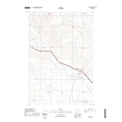
2020 Map of Drummond
USGS Topo · Published 2020About this map
Drummond serves as the central hub of this valley landscape, situated where Flint Creek meets the Clark Fork river. The settlement pattern reflects a long history of ranching and transit, with the town bisected by modern infrastructure that follows the path of older routes like Old Hwy 10A and the historic Mullan Rd. To the north, the foothills of the Garnet Range rise toward King Mtn, cut by a series of steep drainages such as Rattler Gulch and Garden Gulch. To the south, the landscape softens into the agricultural flats of the Flint Creek Valley, where the historic site of New Chicago and the Valley Cem provide significant points of interest for genealogists and local historians. This era of the map captures the transition between the valley's deep ranching roots, evidenced by names like Lorenson Ranch Rd, and its role as a corridor for interstate travel.
Find a feature on this map
43 named features on this map. Tap any name to fly to it.
Don’t see what you’re looking for? This feature index may not catch every label — zoom into the map to look around manually.
Map Details
Editions of this 2020 Drummond Map
This is the sole edition of this map. No revisions or reprints were ever made.
Other maps of this area

1919 · Drummond
USGS Topo · 1:125,000

1921 · Drummond
USGS Topo · 1:125,000

1947 · Butte
USGS Topo · 1:250,000

1958 · Butte
USGS Topo · 1:250,000

1958 · Drummond
USGS Topo · 1:62,500

1959 · Bearmouth
USGS Topo · 1:62,500

1960 · Butte
USGS Topo · 1:250,000

1962 · Butte
USGS Topo · 1:250,000
1965 · Chimney Lakes
USGS Topo · 1:24,000

1965 · Wild Horse Parks
USGS Topo · 1:24,000