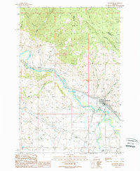
1989 Map of Drummond
USGS Topo · Published 1989About this map
The Clark Fork river valley serves as the central corridor for transport and settlement in this late-century topographic study of Granite and Powell counties. The town of Drummond sits at the junction of several valley systems, where the south-flowing waters of the Flint Creek meet the main river. This landscape is a patchwork of agricultural infrastructure and mountain drainage, featuring extensive irrigation works like the Allendale Ditch and numerous gulches including Rattler Gulch and Edwards Gulch. Evidence of the area's industrial past is visible in the Old Railroad Grade and active Quarries located near Bradman. Smaller named sites such as Ozan and New Chicago provide specific points of interest for genealogists tracing local Montana families, while landmarks like the Fairground near the river fork anchor the community's social geography.
Find a feature on this map
25 named features on this map. Tap any name to fly to it.
Don’t see what you’re looking for? This feature index may not catch every label — zoom into the map to look around manually.
Map Details
Editions of this 1989 Drummond Map
This is the sole edition of this map. No revisions or reprints were ever made.
Other maps of this area

1919 · Drummond
USGS Topo · 1:125,000

1921 · Drummond
USGS Topo · 1:125,000

1947 · Butte
USGS Topo · 1:250,000

1958 · Butte
USGS Topo · 1:250,000

1958 · Drummond
USGS Topo · 1:62,500

1959 · Bearmouth
USGS Topo · 1:62,500

1960 · Butte
USGS Topo · 1:250,000

1962 · Butte
USGS Topo · 1:250,000
1965 · Chimney Lakes
USGS Topo · 1:24,000

1965 · Wild Horse Parks
USGS Topo · 1:24,000